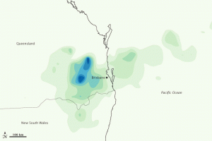
Like everyone else who was stunned by the sudden and unpredicted Toowoomba Floods, I have been looking around for the reason for it. I have driven through Toowoomba. It is flat, high above sea level (by Australian standards) and the last place I would have thought would have suffered from a flash flood. It turns out that the source of the flood water was a very intense localised storm – which turns out to have been captured from low Earth orbit by NASA’s Tropical Rainforest Measuring Mission satellite.
(Text in italics from NASA Earth Observatory Image of the Day) Torrential rain pounded southeast Queensland, Australia, on January 10, 2011, bringing devastating flash floods to several communities just west of Brisbane. This image, made from the Multi-Satellite Precipitation Analysis (MPA) based on data from the Tropical Rainfall Measuring Mission (TRMM), shows the intense rain on January 10.

The storm was relatively concentrated, with the highest rainfall west and northwest of Brisbane. In the darkest blue regions, the TRMM MPA recorded rainfall totals greater than 200 millimeters (8 inches) for the day. Weather stations on the ground reported similar totals.
The rain fell on already saturated ground, said the Australian Bureau of Meteorology. With nowhere to go, the water formed intense flash floods that ripped through the Lockyer Valley, killing ten people and leaving 78 missing, according to news reports. The water drained east, pushing several rivers past major flood stage. Queensland’s largest city and capital, Brisbane, and the nearby city of Ipswich, expected the floods to affect some 45,000 homes by January 12, said Brisbane’s Courier Mail.
The storm continued a trend of rainy weather linked to La Niña. According to the Australian Bureau of Meteorology, Queensland had the wettest December on record in 2010, while the continent as a whole experienced its third wettest year in 2010. The extreme rain triggered widespread flooding across Queensland and New South Wales in December and January.
References and further images of the Queensland Floods taken by NASA satellites can be found on the parent page.
I’ve heard there are or were over 60 unidentified bodies in the morgue in Toowoomba. The stories are horrific, I feel for these people.
I have lived in Toowoomba all my life. Interesting is that the story is the WATER FLOWED EAST!! Infact the water from east and west creak in Toowoomba that flooded flows WEST, out to Oakey and Dalby and beyond. Interesting how the media can get it SO wrong.